
Tag Archives: CompassData
Mapping the 1874 Yavapai-Apache Exodus Trail
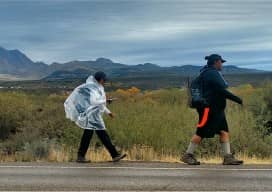
Modern hikers map the Exodus Trail of the Yavapai-Apache Nation with GPS. By Everett Phillips, Philipp Hummel, PLS, and Bryan Frazier; introduction by Judie Piner In 1875, both the Yavapai and the Apache people were removed from their Rio Verde reservation in Arizona and force-marched by U.S. soldiers in terrible conditions, nearly 200 miles, to...

UAV Fly-off
Colorado businesses and non-profits teamed to evaluate UAV technology and to network at this fun event. This spring, a cooperative effort between civil engineering firm CH2M, Juniper Unmanned, the Boy Scouts of America, and local UAS businesses yielded a fun-filled fly-off and network event southeast of Denver, Colorado. Ground Work and Ground Control Alexander Mahrou...
